
Lombardy topographic map
Interactive map
Click on the map to display elevation.
Lombardy
Lombardy has a wide array of climates due to variance in elevation, proximity to inland water basins, and large metropolitan areas. The climate is mainly humid subtropical (Köppen Cfa), especially in the plains, though with significant variations to the Köppen model, especially in the normally long, damp, and cold winters. There is high seasonal temperature variation; in Milan, average temperature is 2.5 °C (36.5 °F) in January and 24 °C (75 °F) in July. The plains are often subject to fog during the coldest months.
About this map
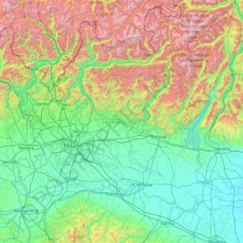
Name: Lombardy topographic map, elevation, terrain.
Location: Lombardy, Italy (44.67991 8.49785 46.63535 11.42765)
Average elevation: 797 m
Minimum elevation: 8 m
Maximum elevation: 3,853 m
Other topographic maps
Click on a map to view its topography, its elevation and its terrain.
St. Anton - Sant'Antonio
Italy > Trentino – Alto Adige/Südtirol > South Tyrol > St. Nikolaus - San Nicolò
Average elevation: 745 m
Sella Nevea
Italy > Friuli – Venezia Giulia > Udine > Chiusaforte
Sella Nevea (Friulian: Nevee, German: Neveasattel, Slovene: Na Žlebeh), at an altitude of 1,195 m (3,921 ft), is a high mountain pass in the Julian Alps, in the Friuli-Venezia Giulia region of northeast Italy. Sella Nevea also lends its name to a frazione of the Chiusaforte municipality and the nearby…
Average elevation: 1,545 m
Etna
Italy > Sicily > Catania > Zafferana Etnea
Eruptions of Etna follow multiple patterns. Most occur at the summit, where there are five distinct craters: the Northeast Crater, the Voragine, the Bocca Nuova, and two at the Southeast Crater Complex. Other eruptions occur on the flanks, which have more than 300 vents ranging in size from small holes in the…
Average elevation: 2,976 m
Tre Cime di Lavaredo - Drei Zinnen
Italy > Veneto > Belluno > Auronzo di Cadore
Until 1919 the peaks formed part of the border between Italy and Austria-Hungary. Now they lie on the border between the Italian provinces of South Tyrol and Belluno and still are a part of the linguistic boundary between German-speaking and Italian-speaking majorities. The Cima Grande has an elevation of…
Average elevation: 2,242 m
Calfosch - Kolfuschg - Colfosco
Italy > Trentino-Alto Adige/Südtirol > South Tyrol
Average elevation: 1,972 m
La battaglia del Monte Castello
Italy > Emilia-Romagna > Bologna > Abetaia
Monte Castello is a hill located about 48 km (30 mi) north of Pistoia (Tuscany) and 60 km (37 mi) southwest of Bologna (Emilia-Romagna), via Località Abetaia (SP623), near Abetaia di Gaggio Montano, coordinates 44.221799, 10.954227, at 977 m (3,205 ft) altitude, in the Northern Apennines. on the border…
Average elevation: 845 m
Mont Vallonnet Nord / Cima las Blancias
Italy > Piedmont > Cuneo > Pietraporzio
Average elevation: 2,522 m
Unterinn - Auna di Sotto
Italy > Trentino-Alto Adige/Südtirol > Ritten - Renon > Unterinn - Auna di Sotto
Average elevation: 843 m
Milland - Millan
Italy > Trentino-Alto Adige/Südtirol > Brixen - Bressanone > Milland - Millan
Average elevation: 769 m
Franz
Italy > Friuli Venezia Giulia > Castelnovo del Friuli > Località Paludea > Franz
Average elevation: 234 m
Case Fonte al Cerro
Italy > Tuscany > Puntone di Scarlino > Case Fonte al Cerro
Average elevation: 36 m
Genoa
Italy > Liguria > Genoa > Genoa
The city of Genoa covers an area of 243 square kilometres (94 sq mi) between the Ligurian Sea and the Apennine Mountains. The city stretches along the coast for about 30 kilometres (19 mi) from the neighbourhood of Voltri to Nervi, and for 10 kilometres (6.2 mi) from the coast to the north along the valleys…
Average elevation: 247 m