
Chame topographic map
Interactive map
Click on the map to display elevation.
About this map
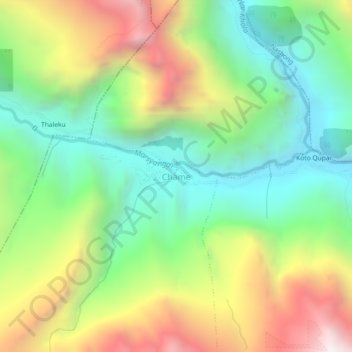
Name: Chame topographic map, elevation, terrain.
Location: Chame, मनाङ, Gandaki, Népal (28.53073 84.22235 28.57073 84.26235)
Average elevation: 3,230 m
Minimum elevation: 2,572 m
Maximum elevation: 4,261 m
Other topographic maps
Click on a map to view its topography, its elevation and its terrain.
Tilicho Lake
Tilicho Lake, Neshyang-09, Neshyang, मनाङ, Gandaki, Népal
Average elevation: 5,062 m