
Friuli-Venezia Giulia topographic map
Interactive map
Click on the map to display elevation.
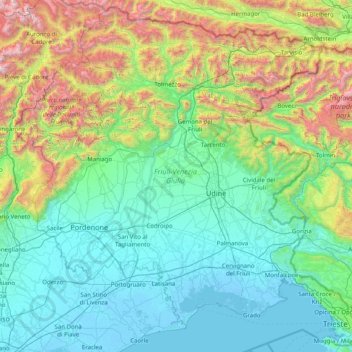
Friuli-Venezia Giulia topographic map, elevation, terrain
Friuli-Venezia Giulia
To the west, the coast is shallow and sandy, with numerous tourist resorts and the lagoons of Grado and Marano Lagunare. To the east, the coastline rises into cliffs, where the Karst Plateau meets the Adriatic, all the way to Trieste and Muggia on the border with Slovenia. The Carso has geological features and phenomena such as hollows, cave networks, and underground rivers, which extend inland in the provinces of Trieste and Gorizia, with an altitude ranging between 300m and 600m.
About this map
Name: Friuli-Venezia Giulia topographic map, elevation, terrain.
Location: Friuli-Venezia Giulia, Italy (45.58090 12.32138 46.64795 13.91866)
Average elevation: 588 m
Minimum elevation: -5 m
Maximum elevation: 3,072 m
Other topographic maps
Click on a map to view its topography, its elevation and its terrain.
Bajardo
Italy > Liguria > Provincia di Imperia
Its principal settlement, Bajardo itself, is a medieval village which stands at an elevation of 900 metres (3,000 ft) on a peak at the head of the basin of the Nervia torrent.
Average elevation: 710 m
Bolzano - Bozen
Italy > Trentino – Alto Adige/Südtirol > South Tyrol
The area of the city of Bolzano is 52.3 km2 (20.2 sq mi), of which 28 km2 (11 sq mi) is used as a settlement area. The city is located in the basin where the Sarntal, Eisacktal, and the Adige Valley with their rivers, Talfer, Eisack, and Adige, meet. In the Middle Ages, the two main Alpine crossings, the Via…
Average elevation: 716 m
Civitella del Tronto
The surrounding mountains have karst topography in the landscapes of the Montagna dei Fiori.
Average elevation: 490 m