
Pomeranian Voivodeship topographic map
Interactive map
Click on the map to display elevation.
About this map
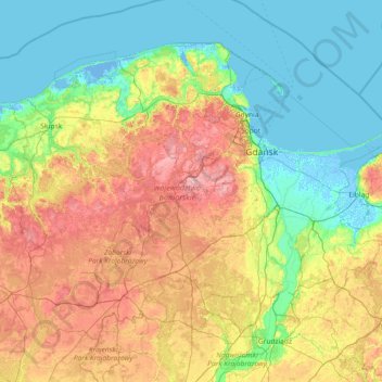
Name: Pomeranian Voivodeship topographic map, elevation, terrain.
Location: Pomeranian Voivodeship, Poland (53.49096 16.69903 54.83642 19.64873)
Average elevation: 76 m
Minimum elevation: -5 m
Maximum elevation: 315 m
Other topographic maps
Click on a map to view its topography, its elevation and its terrain.
Osada Leśna
Poland > Lublin Voivodeship > Włodawa County > Kołacze > Osada Leśna
Average elevation: 170 m