
Thank you for supporting this site ❤️
Make a donation
Make a donation
Northview topographic map
Click on the map to display elevation.
Thank you for supporting this site ❤️
Make a donation
Make a donation
About this map
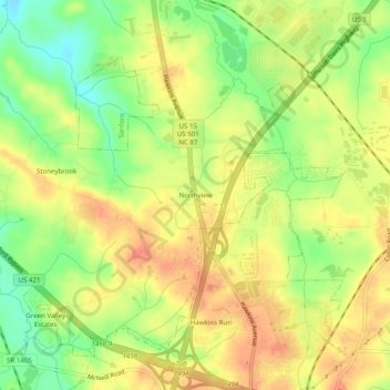
Name: Northview topographic map, elevation, terrain.
Location: Northview, Lee County, North Carolina, 27330, United States (35.50904 -79.20585 35.54904 -79.16585)
Average elevation: 94 m
Minimum elevation: 64 m
Maximum elevation: 115 m
Thank you for supporting this site ❤️
Make a donation
Make a donation
Other topographic maps
Click on a map to view its topography, its elevation and its terrain.
City of Sanford
United States > North Carolina > Lee County > City of Sanford
Average elevation: 115 m