
Thank you for supporting this site ❤️
Make a donation
Make a donation
Ola topographic map
Click on the map to display elevation.
Thank you for supporting this site ❤️
Make a donation
Make a donation
About this map
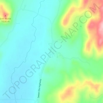
Name: Ola topographic map, elevation, terrain.
Location: Ola, Gem County, Idaho, United States (44.16796 -116.30294 44.18796 -116.28294)
Average elevation: 943 m
Minimum elevation: 897 m
Maximum elevation: 1,062 m
Thank you for supporting this site ❤️
Make a donation
Make a donation
Other topographic maps
Click on a map to view its topography, its elevation and its terrain.
Emmett
United States > Idaho > Gem County
According to the United States Census Bureau, the city has a total area of 2.82 square miles (7.30 km2), of which 2.80 square miles (7.25 km2) is land and 0.02 square miles (0.05 km2) is water. It is located south of the Payette River, at an elevation of 2,362 feet (720 m) above sea level.
Average elevation: 738 m