
Bonbaden topographic map
Interactive map
Click on the map to display elevation.
About this map
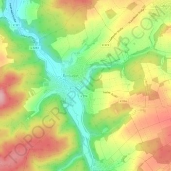
Name: Bonbaden topographic map, elevation, terrain.
Location: Bonbaden, Braunfels, Lahn-Dill-Kreis, Hessen, Deutschland (50.48256 8.39598 50.51637 8.45164)
Average elevation: 234 m
Minimum elevation: 156 m
Maximum elevation: 311 m
Other topographic maps
Click on a map to view its topography, its elevation and its terrain.
Neukirchen
Deutschland > Hessen > Lahn-Dill-Kreis > Braunfels
Neukirchen, Braunfels, Lahn-Dill-Kreis, Hessen, Deutschland
Average elevation: 242 m
Tiefenbach
Deutschland > Hessen > Lahn-Dill-Kreis > Braunfels
Tiefenbach, Braunfels, Lahn-Dill-Kreis, Hessen, 35638, Deutschland
Average elevation: 209 m
Neukirchen
Deutschland > Hessen > Lahn-Dill-Kreis > Braunfels > Neukirchen
Neukirchen, Braunfels, Lahn-Dill-Kreis, Hessen, 35641, Deutschland
Average elevation: 247 m