
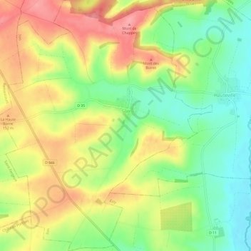
Son topographic map
Interactive map
Click on the map to display elevation.
About this map
Name: Son topographic map, elevation, terrain.
Average elevation: 121 m
Minimum elevation: 74 m
Maximum elevation: 171 m
Other topographic maps
Click on a map to view its topography, its elevation and its terrain.
Olizy-Primat
Olizy-Primat, Vouziers, Ardennes, Grand Est, Metropolitan France, 08250, France
Average elevation: 154 m
Vaux-Champagne
Vaux-Champagne, Vouziers, Ardennes, Grand Est, Metropolitan France, 08130, France
Average elevation: 115 m
Villers-Semeuse
Villers-Semeuse, Charleville-Mézières, Ardennes, Grand Est, Metropolitan France, 08000, France
Average elevation: 159 m
Vrigne-aux-Bois
France > Grand Est > Ardennes > Vrigne aux Bois
Vrigne-aux-Bois, Vrigne aux Bois, Sedan, Ardennes, Grand Est, Metropolitan France, 08330, France
Average elevation: 192 m
Bogny-sur-Meuse
Bogny-sur-Meuse, Charleville-Mézières, Ardennes, Grand Est, Metropolitan France, 08120, France
Average elevation: 242 m
Bassin des Marquisades
France > Grand Est > Ardennes > Les Mazures
Bassin des Marquisades, Les Mazures, Charleville-Mézières, Ardennes, Grand Est, Metropolitan France, 08500, France
Average elevation: 339 m
Forest
France > Grand Est > Ardennes > Seraincourt
Forest, Seraincourt, Rethel, Ardennes, Grand Est, Metropolitan France, 08220, France
Average elevation: 167 m
Nouvion-sur-Meuse
Nouvion-sur-Meuse, Charleville-Mézières, Ardennes, Grand Est, Metropolitan France, 08160, France
Average elevation: 173 m
Gespunsart
Gespunsart, Charleville-Mézières, Ardennes, Grand Est, Metropolitan France, 08700, France
Average elevation: 281 m
Roc la Tour
France > Grand Est > Ardennes > Thilay
Roc la Tour, Senyier, Thilay, Charleville-Mézières, Ardennes, Grand Est, Metropolitan France, 08800, France
Average elevation: 313 m
Servion
France > Grand Est > Ardennes > Rouvroy-sur-Audry
Servion, Rouvroy-sur-Audry, Charleville-Mézières, Ardennes, Grand Est, Metropolitan France, 08150, France
Average elevation: 224 m
Le Grand Hongreaux
France > Grand Est > Ardennes > Rocroi
Le Grand Hongreaux, Rocroi, Charleville-Mézières, Ardennes, Grand Est, Metropolitan France, 08230, France
Average elevation: 362 m
Mont Vireux
France > Grand Est > Ardennes > Vireux-Molhain
Mont Vireux, Vireux-Molhain, Charleville-Mézières, Ardennes, Grand Est, Metropolitan France, 08320, France
Average elevation: 151 m
Vireux-Molhain
Vireux-Molhain, Charleville-Mézières, Ardennes, Grand Est, Metropolitan France, 08320, France
Average elevation: 173 m
Richat
France > Grand Est > Ardennes > Fromelennes
Richat, Fromelennes, Charleville-Mézières, Ardennes, Grand Est, Metropolitan France, 08600, France
Average elevation: 165 m
Thin-le-Moutier
Thin-le-Moutier, Charleville-Mézières, Ardennes, Grand Est, Metropolitan France, 08460, France
Average elevation: 239 m
Les Hautes-Rivières
Les Hautes-Rivières, Charleville-Mézières, Ardennes, Grand Est, Metropolitan France, 08800, France
Average elevation: 337 m
Charleville-Mézières
Charleville-Mézières, Ardennes, Grand Est, Metropolitan France, 08000, France
Average elevation: 201 m