
Upper Barneys River topographic map
Interactive map
Click on the map to display elevation.
About this map
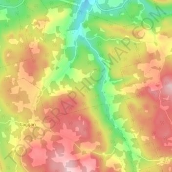
Name: Upper Barneys River topographic map, elevation, terrain.
Average elevation: 196 m
Minimum elevation: 75 m
Maximum elevation: 302 m
Other topographic maps
Click on a map to view its topography, its elevation and its terrain.
Caribou River
Canada > Nova Scotia > Municipality of Pictou County
Caribou River, Municipality of Pictou County, Pictou County, Nova Scotia, Canada
Average elevation: 12 m
River John
Canada > Nova Scotia > Municipality of Pictou County
River John, Municipality of Pictou County, Pictou County, Nova Scotia, B0K 1N0, Canada
Average elevation: 16 m
East River St. Marys
Canada > Nova Scotia > Municipality of Pictou County
East River St. Marys, Municipality of Pictou County, Pictou County, Nova Scotia, Canada
Average elevation: 128 m
Thorburn
Canada > Nova Scotia > Municipality of Pictou County
Thorburn, Municipality of Pictou County, Pictou County, Nova Scotia, Canada
Average elevation: 66 m
Marshville
Canada > Nova Scotia > Municipality of Pictou County
Marshville, Municipality of Pictou County, Pictou County, Nova Scotia, Canada
Average elevation: 11 m
Riverton
Canada > Nova Scotia > Municipality of Pictou County
Riverton, Municipality of Pictou County, Pictou County, Nova Scotia, Canada
Average elevation: 76 m
Hazel Glen
Canada > Nova Scotia > Municipality of Pictou County
Hazel Glen, Municipality of Pictou County, Pictou County, Nova Scotia, Canada
Average elevation: 66 m
Hopewell
Canada > Nova Scotia > Municipality of Pictou County
Hopewell, Municipality of Pictou County, Pictou County, Nova Scotia, Canada
Average elevation: 107 m
Plainfield
Canada > Nova Scotia > Municipality of Pictou County
Plainfield, Municipality of Pictou County, Pictou County, Nova Scotia, Canada
Average elevation: 95 m
Sunny Brae
Canada > Nova Scotia > Municipality of Pictou County
Sunny Brae, Municipality of Pictou County, Pictou County, Nova Scotia, Canada
Average elevation: 172 m
Glencoe
Canada > Nova Scotia > Municipality of Pictou County
Glencoe, Municipality of Pictou County, Pictou County, Nova Scotia, Canada
Average elevation: 161 m
Durham
Canada > Nova Scotia > Municipality of Pictou County
Durham, Municipality of Pictou County, Pictou County, Nova Scotia, Canada
Average elevation: 46 m
Mount Thom
Canada > Nova Scotia > Municipality of Pictou County
Mount Thom, Municipality of Pictou County, Pictou County, Nova Scotia, Canada
Average elevation: 203 m
Scotsburn
Canada > Nova Scotia > Municipality of Pictou County
Scotsburn, Municipality of Pictou County, Pictou County, Nova Scotia, B0K 1R0, Canada
Average elevation: 102 m
Kenzieville
Canada > Nova Scotia > Municipality of Pictou County
Kenzieville, Municipality of Pictou County, Pictou County, Nova Scotia, Canada
Average elevation: 127 m
Ponds
Canada > Nova Scotia > Municipality of Pictou County
Ponds, Municipality of Pictou County, Pictou County, Nova Scotia, Canada
Average elevation: 29 m
Campbell Hill
Canada > Nova Scotia > Municipality of Pictou County
Campbell Hill, Municipality of Pictou County, Pictou County, Nova Scotia, Canada
Average elevation: 151 m