Geolocate

Balindong topographic map

Interactive map

Click on the map to display elevation.

About this map

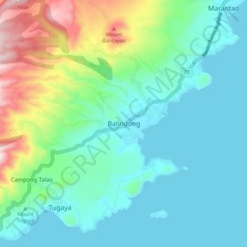
Name: Balindong topographic map, elevation, terrain.

Location: Balindong, Lanao del Sur, Bangsamoro, 9318, Philippines (7.87094 124.15893 7.95094 124.23893)

Average elevation: 822 m

Minimum elevation: 691 m

Maximum elevation: 1,252 m

Other topographic maps

Click on a map to view its topography, its elevation and its terrain.

Kapatagan

Philippines > Lanao del Sur

Average elevation: 220 m

Amai Manabilang

Philippines > Lanao del Sur

Mountain ranges, hills, plateaus, and flatland characterize the topography of the barangay. It has a vast agricultural land suited for crops like rice, corn, carrots, sugar cane. Its hydrological features comprise rivers like the Maridugao and Sumogot, streams, swamps, creeks and springs.

Average elevation: 969 m

Tubok

Philippines > Lanao del Sur

Average elevation: 701 m

Poona Bayabao

Philippines > Lanao del Sur

Average elevation: 725 m

Kapatagan

Philippines > Lanao del Sur

Average elevation: 297 m

Bacolod-Kalawi

Philippines > Lanao del Sur

Average elevation: 854 m

Marantao

Philippines > Lanao del Sur

Average elevation: 793 m

Madamba

Philippines > Lanao del Sur

Average elevation: 1,135 m

Marawi

Philippines > Lanao del Sur

Marawi is located upon the shores of Lake Lanao. It is primarily inhabited by the Maranao people. The city is also called the "summer capital of the south" due to its higher elevation and cooler climate, a nickname it shares with Malaybalay.

Average elevation: 707 m

Kapai

Philippines > Lanao del Sur

Average elevation: 693 m

Saguiaran

Philippines > Lanao del Sur > Saguiaran

Average elevation: 662 m