
Thank you for supporting this site ❤️
Make a donation
Make a donation
Maletto topographic map
Click on the map to display elevation.
Thank you for supporting this site ❤️
Make a donation
Make a donation
Maletto
The geographical location of Maletto also influences its climate. The town experiences a Mediterranean climate, characterized by hot, dry summers and mild, rainy winters. However, due to its proximity to Mount Etna, microclimates can be observed, with variations in temperature and precipitation depending on altitude and local conditions.
Thank you for supporting this site ❤️
Make a donation
Make a donation
About this map
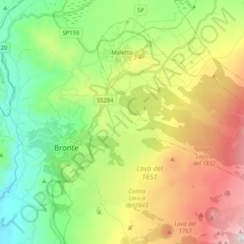
Name: Maletto topographic map, elevation, terrain.
Location: Maletto, Catania, Sicily, 95035, Italy (37.75103 14.85167 37.84702 14.99403)
Average elevation: 983 m
Minimum elevation: 458 m
Maximum elevation: 1,855 m
Thank you for supporting this site ❤️
Make a donation
Make a donation
Other topographic maps
Click on a map to view its topography, its elevation and its terrain.