
Thank you for supporting this site ❤️
Make a donation
Make a donation
Bermuda Dunes topographic map
Click on the map to display elevation.
Thank you for supporting this site ❤️
Make a donation
Make a donation
Bermuda Dunes
According to the United States Census Bureau, the CDP has a total area of 2.9 square miles (7.5 km2), all of it land. The official elevation of Bermuda Dunes is 30 feet (9.1 m) above sea level, but the surface drops by over 80 feet (24 m) from west to east.
Thank you for supporting this site ❤️
Make a donation
Make a donation
About this map
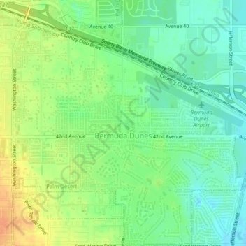
Name: Bermuda Dunes topographic map, elevation, terrain.
Average elevation: 27 m
Minimum elevation: 11 m
Maximum elevation: 48 m
Thank you for supporting this site ❤️
Make a donation
Make a donation
Other topographic maps
Click on a map to view its topography, its elevation and its terrain.