
Péaule topographic map
Interactive map
Click on the map to display elevation.
About this map
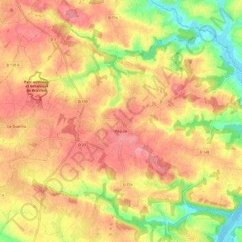
Name: Péaule topographic map, elevation, terrain.
Average elevation: 56 m
Minimum elevation: -4 m
Maximum elevation: 92 m
Other topographic maps
Click on a map to view its topography, its elevation and its terrain.
Route du Stade
France > Bretagne > Morbihan > Saint-Gravé
Route du Stade, Saint-Gravé, Vannes, Morbihan, Bretagne, France métropolitaine, 56220, France
Average elevation: 69 m
Port de Roche
France > Bretagne > Morbihan > La Gacilly
Port de Roche, Glénac, La Gacilly, Vannes, Morbihan, Bretagne, France métropolitaine, 56200, France
Average elevation: 30 m
La Croix Neuve
France > Bretagne > Morbihan > Séné
La Croix Neuve, Séné, Vannes, Morbihan, Bretagne, France métropolitaine, 56860, France
Average elevation: 3 m
Le Bihor
France > Bretagne > Morbihan > Plouharnel
Le Bihor, Plouharnel, Lorient, Morbihan, Bretagne, France métropolitaine, 56340, France
Average elevation: 13 m
Saint-Gildas-de-Rhuys
Saint-Gildas-de-Rhuys, Vannes, Morbihan, Bretagne, France métropolitaine, 56730, France
Average elevation: 12 m