
Thank you for supporting this site ❤️
Make a donation
Make a donation
Lucena topographic map
Click on the map to display elevation.
Thank you for supporting this site ❤️
Make a donation
Make a donation
Lucena
Lucena is located in the transition zone between the campiña in the Guadalquivir Depression and the Subbaetic system, at an altitude above mean sea level slightly below 500 meters. The Subbaetic system include neighboring subranges such as the sierras of Cabra, Carcabuey, Pollos, Horconera, and Rute.
Thank you for supporting this site ❤️
Make a donation
Make a donation
About this map
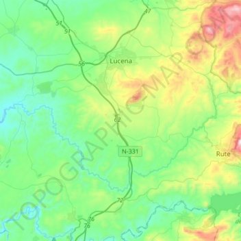
Name: Lucena topographic map, elevation, terrain.
Location: Lucena, Córdoba, Andalusia, Spain (37.24670 -4.68407 37.46382 -4.41701)
Average elevation: 476 m
Minimum elevation: 241 m
Maximum elevation: 1,151 m
Thank you for supporting this site ❤️
Make a donation
Make a donation
Other topographic maps
Click on a map to view its topography, its elevation and its terrain.
Montenegral Alto
Spain > Andalusia > Campo de Gibraltar > San Martín del Tesorillo
Average elevation: 71 m
Thank you for supporting this site ❤️
Make a donation
Make a donation