
Chalandri topographic map
Interactive map
Click on the map to display elevation.
About this map
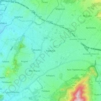
Name: Chalandri topographic map, elevation, terrain.
Average elevation: 222 m
Minimum elevation: 110 m
Maximum elevation: 685 m
Other topographic maps
Click on a map to view its topography, its elevation and its terrain.
Olympus
Greece > Attica > Regional Unit of North Athens > Municipal Unit of Psychiko
Olympus, Municipal Unit of Psychiko, Municipality of Filothei - Psychiko, Regional Unit of North Athens, Attica, 154 52, Greece
Average elevation: 204 m