
Make a donation
Beirut topographic map
Click on the map to display elevation.
Make a donation
Beirut
The average annual rainfall is 825 millimetres (32.5 in), with the large majority of it falling from October to April. Much of the autumn and spring rain falls in heavy downpours on a limited number of days, but in winter it is spread more evenly over many days. Summer receives very little rainfall, if any. Snow is rare, except in the mountainous eastern suburbs, where snowfall occurs due to the region's high altitudes. Hail (which can often be heavy) occurs a few times per year, mostly during winter.
Make a donation
About this map
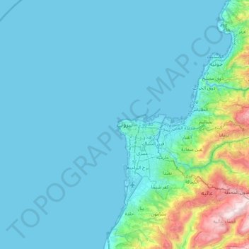
Name: Beirut topographic map, elevation, terrain.
Location: Beirut, El Hamra, 2034 1111, Lebanon (33.73592 35.31843 34.05592 35.63843)
Average elevation: 145 m
Minimum elevation: -2 m
Maximum elevation: 1,257 m
Make a donation
Other topographic maps
Click on a map to view its topography, its elevation and its terrain.
Tyre
Since 2008, a Lebanese French team under the direction by Pierre-Louis Gatier of the University of Lyon has been conducting archaeological and topographical work. When international archeological missions in Syria came to a halt after 2012 due to the war there, some of them instead started excavations in Tyre,…
Average elevation: 5 m