
Thank you for supporting this site ❤️
Make a donation
Make a donation
Krowodrza topographic map
Click on the map to display elevation.
Thank you for supporting this site ❤️
Make a donation
Make a donation
About this map
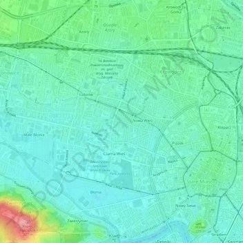
Name: Krowodrza topographic map, elevation, terrain.
Location: Krowodrza, Krakow, Lesser Poland Voivodeship, Poland (50.05916 19.88724 50.08266 19.94736)
Average elevation: 218 m
Minimum elevation: 195 m
Maximum elevation: 299 m
Thank you for supporting this site ❤️
Make a donation
Make a donation
Other topographic maps
Click on a map to view its topography, its elevation and its terrain.