
Thank you for supporting this site ❤️
Make a donation
Make a donation
Locust topographic map
Click on the map to display elevation.
Thank you for supporting this site ❤️
Make a donation
Make a donation
About this map
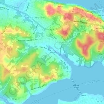
Name: Locust topographic map, elevation, terrain.
Average elevation: 26 m
Minimum elevation: -2 m
Maximum elevation: 80 m
Thank you for supporting this site ❤️
Make a donation
Make a donation
Other topographic maps
Click on a map to view its topography, its elevation and its terrain.
Leonardo
United States > New Jersey > Monmouth County > Middletown Township > Leonardo
Average elevation: 6 m
Navesink
United States > New Jersey > Monmouth County > Middletown Township > Navesink
Average elevation: 27 m
Port Monmouth
United States > New Jersey > Monmouth County > Middletown Township
Average elevation: 3 m
Thank you for supporting this site ❤️
Make a donation
Make a donation