
Skykomish topographic map
Interactive map
Click on the map to display elevation.
About this map
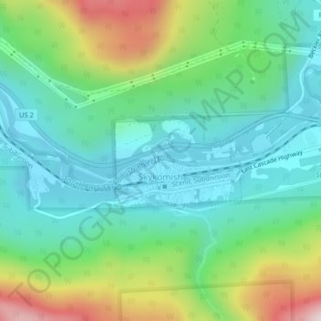
Name: Skykomish topographic map, elevation, terrain.
Location: Skykomish, King County, Washington, United States (47.70656 -121.36627 47.71466 -121.34446)
Average elevation: 441 m
Minimum elevation: 270 m
Maximum elevation: 857 m
Other topographic maps
Click on a map to view its topography, its elevation and its terrain.
Seattle
United States > Washington > King County
The city itself is hilly, though not uniformly so. Like Rome, the city is said to lie on seven hills; the lists vary but typically include Capitol Hill, First Hill, West Seattle, Beacon Hill, Queen Anne, Magnolia, and the former Denny Hill. The Wallingford, Delridge, Mount Baker, Seward Park, Washington Park,…
Average elevation: 40 m