
Make a donation
Eastern Development Region topographic map
Click on the map to display elevation.
Make a donation
About this map
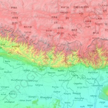
Name: Eastern Development Region topographic map, elevation, terrain.
Location: Eastern Development Region, Nepal (24.81597 84.80629 30.01597 90.00629)
Average elevation: 2,441 m
Minimum elevation: 9 m
Maximum elevation: 8,419 m
Make a donation
Other topographic maps
Click on a map to view its topography, its elevation and its terrain.
Dolakha
Dolakha is also home to another holy temple - Kalinchowk Bhagawati. It is situated in high mountains at an altitude of about 3842m and the pilgrims are known to walk a long and dangerous route via the mountains to the temple. But, in 2018 the government started a new cable car service for the comfort of the…
Average elevation: 3,452 m
Kanchanpur District
Nepal > Sudurpashchim Province
The district expands from 28 degrees 38 minutes to 29 degrees 28 minutes Northern latitudes and 80 degrees 03 minutes to 80 degrees 33 minutes Eastern longitudes. It is situated at the end of westmost part of province and country on the corner of the south-west. Geographically it is on the terai, but the…
Average elevation: 333 m
Make a donation
Make a donation