
Thank you for supporting this site ❤️
Make a donation
Make a donation
Dolakha topographic map
Click on the map to display elevation.
Thank you for supporting this site ❤️
Make a donation
Make a donation
Dolakha
Dolakha is also home to another holy temple - Kalinchowk Bhagawati. It is situated in high mountains at an altitude of about 3842m and the pilgrims are known to walk a long and dangerous route via the mountains to the temple. But, in 2018 the government started a new cable car service for the comfort of the pilgrims. The temple is believed to have strong spiritual power and is known to fulfil the prayers of the pilgrims.
Thank you for supporting this site ❤️
Make a donation
Make a donation
About this map
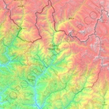
Name: Dolakha topographic map, elevation, terrain.
Location: Dolakha, Bagmati Province, Nepal (27.47388 85.88428 28.17381 86.55475)
Average elevation: 3,452 m
Minimum elevation: 699 m
Maximum elevation: 7,206 m
Thank you for supporting this site ❤️
Make a donation
Make a donation
Other topographic maps
Click on a map to view its topography, its elevation and its terrain.