
Thank you for supporting this site ❤️
Make a donation
Make a donation
Visakhapatnam topographic map
Click on the map to display elevation.
Thank you for supporting this site ❤️
Make a donation
Make a donation
Visakhapatnam
The city is situated between the Eastern Ghats and the Bay of Bengal. The city coordinates lies between 17.7041 N and 83.2977 E. The city's area is 682 km2. The average elevation is 45 metres. Visakhpatnam is situated in Coastal Andhra Region.
Thank you for supporting this site ❤️
Make a donation
Make a donation
About this map
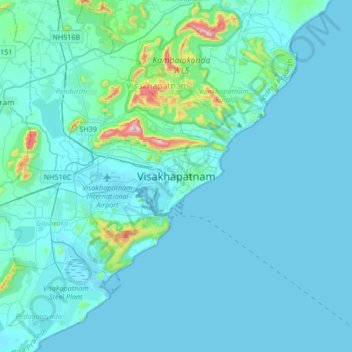
Name: Visakhapatnam topographic map, elevation, terrain.
Average elevation: 41 m
Minimum elevation: -2 m
Maximum elevation: 519 m
Thank you for supporting this site ❤️
Make a donation
Make a donation