
Thank you for supporting this site ❤️
Make a donation
Make a donation
Kopua topographic map
Click on the map to display elevation.
Thank you for supporting this site ❤️
Make a donation
Make a donation
About this map
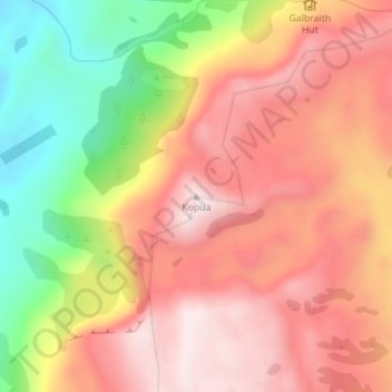
Name: Kopua topographic map, elevation, terrain.
Location: Kopua, Hastings District, Hawke's Bay, New Zealand (-39.16295 176.70649 -39.16285 176.70659)
Average elevation: 851 m
Minimum elevation: 522 m
Maximum elevation: 1,076 m
Hastings District trails, hiking, mountain biking, running and outdoor activities
Thank you for supporting this site ❤️
Make a donation
Make a donation
Other topographic maps
Click on a map to view its topography, its elevation and its terrain.