
Llandaff topographic map
Interactive map
Click on the map to display elevation.
About this map
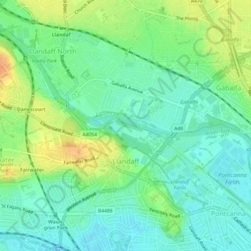
Name: Llandaff topographic map, elevation, terrain.
Location: Llandaff, Cardiff, Pays de Galles, CF, Royaume-Uni (51.48680 -3.24967 51.50907 -3.20660)
Average elevation: 21 m
Minimum elevation: 7 m
Maximum elevation: 45 m
Other topographic maps
Click on a map to view its topography, its elevation and its terrain.
Pontprennau
Royaume-Uni > Pays de Galles > Cardiff
Pontprennau, Cardiff, Pays de Galles, CF, Royaume-Uni
Average elevation: 62 m
Castle
Royaume-Uni > Pays de Galles > Cardiff
Castle, Cardiff, Pays de Galles, CF, Royaume-Uni
Average elevation: 14 m