
Crooked River topographic map
Interactive map
Click on the map to display elevation.
About this map
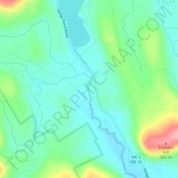
Name: Crooked River topographic map, elevation, terrain.
Location: Crooked River, Oxford County, Maine, 04217, USA (44.34134 -70.78650 44.34516 -70.78556)
Average elevation: 226 m
Minimum elevation: 191 m
Maximum elevation: 323 m
Other topographic maps
Click on a map to view its topography, its elevation and its terrain.
Bryant Pond
USA > Maine > Bryant Pond
Bryant Pond, Oxford County, Maine, 04255, USA
Average elevation: 270 m
Cunningham Mountains
Cunningham Mountains, Penobscot County, Maine, USA
Average elevation: 262 m
Pleasant River
Pleasant River, Washington County, Maine, 04632, USA
Average elevation: 29 m