
Ikeda topographic map
Interactive map
Click on the map to display elevation.
About this map
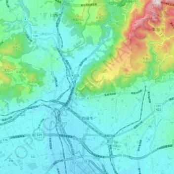
Name: Ikeda topographic map, elevation, terrain.
Location: Ikeda, Préfecture d'Osaka, Japon (34.79177 135.41599 34.87713 135.46081)
Average elevation: 124 m
Minimum elevation: 11 m
Maximum elevation: 594 m
Other topographic maps
Click on a map to view its topography, its elevation and its terrain.
浜寺船尾町西はまなす広場
Japon > Préfecture d'Osaka > Sakai
浜寺船尾町西はまなす広場, 12, 浜寺諏訪森町中三丁, 西区, Sakai, Préfecture d'Osaka, 592-8342, Japon
Average elevation: 6 m