
Long Island topographic map
Click on the map to display elevation.
Long Island
Long Island’s topography is a low, elongated glacial landscape, shaped less by bedrock relief than by the deposits left at the southern margin of the last ice sheets. Its main relief is organized around two broad terminal-moraine belts—the Harbor Hill moraine along much of the North Shore and the Ronkonkoma moraine through the island’s interior—which form gently rolling ridges of sand, gravel, and till, while the land southward grades into flatter sandy outwash plains and barrier-beach systems facing the Atlantic. Elevations are modest overall, rising from sea level along Long Island Sound, the bays, and the ocean beaches to the island’s highest natural ground at Jayne’s Hill, about 401 feet (122 meters), in the West Hills area. The North Shore is generally more irregular, with short valleys, bluffs, and locally steep slopes descending toward the Sound, whereas the South Shore is broader, lower, and smoother, marked by wetlands, lagoons, tidal inlets, and long barrier islands. Overall, Long Island presents the physical character of a subdued but distinctly glacial coastal plain: gently undulating inland ridges, sandy aquifer-bearing deposits, low coastal flats, and a shoreline shaped by the contrast between moraine-built northern terrain and wave-reworked southern beaches.
About this map
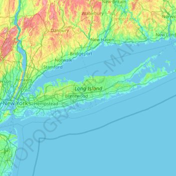
Name: Long Island topographic map, elevation, terrain.
Location: Long Island, New York, United States (40.54190 -74.04197 41.16116 -71.85627)
Average elevation: 42 m
Minimum elevation: -5 m
Maximum elevation: 498 m
Other topographic maps
Click on a map to view its topography, its elevation and its terrain.
Central Park
United States > New York > New York County > New York
In June 1856, Fernando Wood appointed a "consulting board" of seven people, headed by author Washington Irving, to inspire public confidence in the proposed development. Wood hired military engineer Egbert Ludovicus Viele as the park's chief engineer, tasking him with a topographical survey of the site. The…
Average elevation: 26 m
Quaker Ridge
United States > New York > Westchester County > City of New Rochelle
Average elevation: 65 m