
Thank you for supporting this site ❤️
Make a donation
Make a donation
Grasmere Lake topographic map
Click on the map to display elevation.
Thank you for supporting this site ❤️
Make a donation
Make a donation
About this map
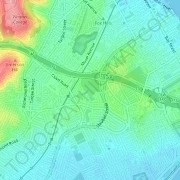
Name: Grasmere Lake topographic map, elevation, terrain.
Location: Grasmere Lake, Staten Island, New York, United States (40.60239 -74.08249 40.60576 -74.07835)
Average elevation: 27 m
Minimum elevation: -1 m
Maximum elevation: 108 m
Thank you for supporting this site ❤️
Make a donation
Make a donation
Other topographic maps
Click on a map to view its topography, its elevation and its terrain.
New York County
United States > New York > New York
Parkland covers a total of 2,659 acres (10.76 km2), accounting for 18.2% of the borough's land area; the 840-acre (3.4 km2) Central Park is the borough's largest park, comprising 31.6% of Manhattan's parkland. Designed by Frederick Law Olmsted and Calvert Vaux, the park is anchored by the 12-acre (4.9 ha)…
Average elevation: 16 m