
Make a donation
Epirus topographic map
Click on the map to display elevation.
Make a donation
Epirus
Greek Epirus, like the region as a whole, is rugged and mountainous. It comprises the land of the ancient Molossians and Thesprotians and a small part of the land of the Chaonians, the greater part being in Southern Albania. It is largely made up of mountainous ridges, part of the Dinaric Alps. The region's highest spot is on Mount Smolikas, at an altitude of 2,637 metres (8,652 ft) above sea level. In the east, the Pindus Mountains that form the spine of mainland Greece separate Epirus from Macedonia and Thessaly. Most of Epirus lies on the windward side of the Pindus. The winds from the Ionian Sea offer the region more rainfall than any other part of Greece.
Make a donation
About this map
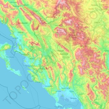
Name: Epirus topographic map, elevation, terrain.
Location: Epirus, Epirus and Western Macedonia, Greece (38.92369 19.98922 40.37660 21.43002)
Average elevation: 603 m
Minimum elevation: -5 m
Maximum elevation: 2,592 m
Make a donation
Other topographic maps
Click on a map to view its topography, its elevation and its terrain.
Σέρβια
Greece > Epirus and Western Macedonia > Kozani Regional Unit > Servia Municipal Unit
The Philharmonic band of the town, established in 1928, is run by the "Morphotikos Omilos Servion", which is the main Cultural Society of the town. It organises a wide range of cultural events and supports teaching classes for children and adults in painting, dance, choir, and chess. Hang gliding is prominent…
Average elevation: 565 m
Φαράγγι Βίκου
Greece > Epirus and Western Macedonia > Ioannina Regional Unit
Average elevation: 1,090 m
Make a donation
Χρυσογιάλι
Greece > Epirus and Western Macedonia > Preveza Regional Unit > Parga
Average elevation: 129 m
Make a donation
Make a donation
Make a donation
Φαράγγι Βίκου
Greece > Epirus and Western Macedonia > Ioannina Regional Unit
Average elevation: 1,159 m
Ioannina
Greece > Epirus and Western Macedonia > Ioannina Regional Unit
According to the 2021 census, the city population was 64,896 while the municipality had 113,978 inhabitants. It lies at an elevation of approximately 500 metres (1,640 feet) above sea level, on the western shore of Lake Pamvotis (Παμβώτις). Ioannina is located 410 km (255 mi) northwest of Athens, 260…
Average elevation: 724 m
Make a donation
Κατσικάς
Greece > Epirus and Western Macedonia > Ioannina Regional Unit > Pamvotida Municipal Unit
Average elevation: 494 m
Make a donation
Nymfeo
Greece > Epirus and Western Macedonia > Florina Regional Unit
Nymfaio is a mountain village, situated at 1350 m elevation in the densely forested Verno mountains. It is 3 km north of Sklithro, 5 km west of Aetos, 16 km west of Amyntaio and 17 km southeast of Florina.
Average elevation: 1,214 m
Ioannina
Greece > Epirus and Western Macedonia > Ioannina Regional Unit
Ioannina (Greek: Ιωάννινα Ioánnina [i.oˈa.ni.na] (listen)), often called Yannena (Γιάννενα Yánnena [ˈʝa.ne.na]) within Greece, is the capital and largest city of the Ioannina regional unit and of Epirus, an administrative region in north-western Greece. According to the 2011 census, the…
Average elevation: 724 m
Make a donation
Πανεπιστημιούπολη
Greece > Epirus and Western Macedonia > Ioannina Regional Unit > Ioannina > Νεοχωρόπουλο
Average elevation: 538 m
Make a donation
Ανάληψη
Greece > Epirus and Western Macedonia > Florina Regional Unit > Amyndeo
Average elevation: 591 m
Psarades
Greece > Epirus and Western Macedonia > Florina Regional Unit > Prespes Municipal Unit
Average elevation: 919 m
Make a donation
Μικρό Πάπιγκο
Greece > Epirus and Western Macedonia > Ioannina Regional Unit
Average elevation: 1,241 m
Make a donation
Κήποι
Greece > Epirus and Western Macedonia > Ioannina Regional Unit
Kipoi (Greek: Κήποι, before 1928: Μπάγια – Bagia) is a village in the region of Zagori. It belongs to the municipal unit of Tymfi, Ioannina regional unit, Greece. The Greek name derives from the many gardens in the surrounding areas (Greek Κήποι=Gardens). The name "Bagia" is Slavic and means…
Average elevation: 871 m
Make a donation
Samarina
Greece > Epirus and Western Macedonia > Grevena Regional Unit
Samarina is located on an eastern spur of Mount Smolikas, the highest of the Pindus range and the second-highest mountain in all of Greece. At an altitude of 1380–1515 meters (4528' to 4970'), it is considered one of the highest villages in Greece and also one of the highest in the Balkans; its height puts…
Average elevation: 1,558 m
Pisoderi
Greece > Epirus and Western Macedonia > Florina Regional Unit > Prespes Municipal Unit
Average elevation: 1,602 m
Falakro (Vitsi)
Greece > Epirus and Western Macedonia > Florina Regional Unit > Prespes Municipal Unit
Average elevation: 1,632 m
Make a donation
Florina
Greece > Epirus and Western Macedonia > Florina Regional Unit
Florina is one of the coldest towns in Greece, because of its elevation and geographic position. Heavy snowfalls, thick fog and below-freezing temperatures are common during the winter months, while the summers are mild. Under the Köppen climate classification, Florina has a humid subtropical climate (Cfa)…
Average elevation: 999 m
Make a donation
Make a donation