
Thank you for supporting this site ❤️
Make a donation
Make a donation
Biskra topographic map
Click on the map to display elevation.
Thank you for supporting this site ❤️
Make a donation
Make a donation
About this map
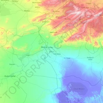
Name: Biskra topographic map, elevation, terrain.
Location: Biskra, Algeria (34.28284 4.92519 35.28565 6.77252)
Average elevation: 427 m
Minimum elevation: -32 m
Maximum elevation: 2,275 m
Thank you for supporting this site ❤️
Make a donation
Make a donation
Other topographic maps
Click on a map to view its topography, its elevation and its terrain.