
Thank you for supporting this site ❤️
Make a donation
Make a donation
Muxagata topographic map
Click on the map to display elevation.
Thank you for supporting this site ❤️
Make a donation
Make a donation
About this map
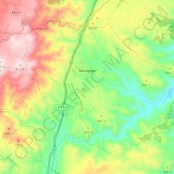
Name: Muxagata topographic map, elevation, terrain.
Location: Muxagata, Vila Nova de Foz Côa, Guarda, 5150-307, Portugal (41.00180 -7.20310 41.05631 -7.10816)
Average elevation: 397 m
Minimum elevation: 141 m
Maximum elevation: 719 m
Thank you for supporting this site ❤️
Make a donation
Make a donation
Other topographic maps
Click on a map to view its topography, its elevation and its terrain.
Miradouro de Horta do Douro
Portugal > Guarda > Vila Nova de Foz Côa > Horta > Senhora da Estrada
Average elevation: 563 m