
Thank you for supporting this site ❤️
Make a donation
Make a donation
Yardley topographic map
Click on the map to display elevation.
Thank you for supporting this site ❤️
Make a donation
Make a donation
About this map
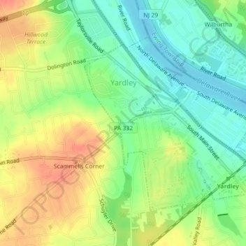
Name: Yardley topographic map, elevation, terrain.
Location: Yardley, Bucks County, Pennsylvania, United States (40.23162 -74.85164 40.25072 -74.82409)
Average elevation: 29 m
Minimum elevation: 6 m
Maximum elevation: 56 m
Thank you for supporting this site ❤️
Make a donation
Make a donation
Other topographic maps
Click on a map to view its topography, its elevation and its terrain.
Feasterville
United States > Pennsylvania > Bucks County > Lower Southampton Township
Average elevation: 66 m