
Thank you for supporting this site ❤️
Make a donation
Make a donation
Blue Mound topographic map
Click on the map to display elevation.
Thank you for supporting this site ❤️
Make a donation
Make a donation
About this map
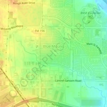
Name: Blue Mound topographic map, elevation, terrain.
Location: Blue Mound, Tarrant County, Texas, United States (32.84774 -97.34297 32.86157 -97.33307)
Average elevation: 207 m
Minimum elevation: 190 m
Maximum elevation: 219 m
Thank you for supporting this site ❤️
Make a donation
Make a donation
Other topographic maps
Click on a map to view its topography, its elevation and its terrain.
Summerfields/Chisholm Park
United States > Texas > Tarrant County > Fort Worth
Average elevation: 203 m
Thank you for supporting this site ❤️
Make a donation
Make a donation
Thank you for supporting this site ❤️
Make a donation
Make a donation
Thank you for supporting this site ❤️
Make a donation
Make a donation
Thank you for supporting this site ❤️
Make a donation
Make a donation
Will Rogers Memorial Center
United States > Texas > Tarrant County > Fort Worth
Average elevation: 181 m