
Thank you for supporting this site ❤️
Make a donation
Make a donation
Catlins River topographic map
Click on the map to display elevation.
Thank you for supporting this site ❤️
Make a donation
Make a donation
About this map
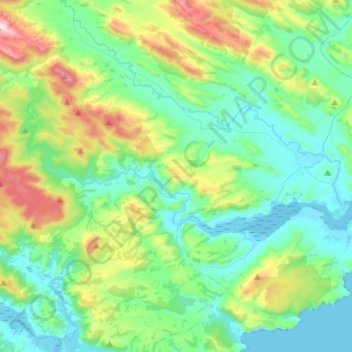
Name: Catlins River topographic map, elevation, terrain.
Location: Catlins River, Clutha District, New Zealand (-46.48556 169.43945 -46.42457 169.71758)
Average elevation: 152 m
Minimum elevation: -1 m
Maximum elevation: 595 m
Clutha District trails, hiking, mountain biking, running and outdoor activities
Thank you for supporting this site ❤️
Make a donation
Make a donation
Other topographic maps
Click on a map to view its topography, its elevation and its terrain.
Lake Mahinerangi
The lake is well stocked with brown trout and some perch. The elevation is nearly 2,000 feet (610 m) and the lake can be very windswept and cold, which makes the fishery best suited to the warmer months.
Average elevation: 446 m
Thank you for supporting this site ❤️
Make a donation
Make a donation