
Thank you for supporting this site ❤️
Make a donation
Make a donation
Westernport topographic map
Click on the map to display elevation.
Thank you for supporting this site ❤️
Make a donation
Make a donation
About this map
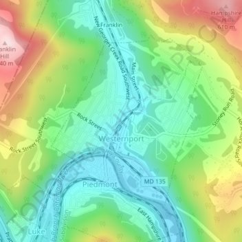
Name: Westernport topographic map, elevation, terrain.
Location: Westernport, Allegany County, Maryland, United States (39.47770 -79.05481 39.49708 -79.03302)
Average elevation: 400 m
Minimum elevation: 267 m
Maximum elevation: 648 m
Thank you for supporting this site ❤️
Make a donation
Make a donation
Other topographic maps
Click on a map to view its topography, its elevation and its terrain.