
Thank you for supporting this site ❤️
Make a donation
Make a donation
Santa Escolastica topographic map
Click on the map to display elevation.
Thank you for supporting this site ❤️
Make a donation
Make a donation
About this map
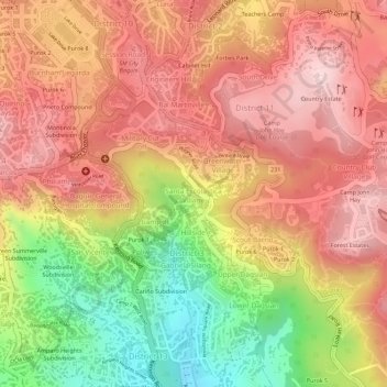
Name: Santa Escolastica topographic map, elevation, terrain.
Location: Santa Escolastica, District 3, Baguio, 2600, Philippines (16.39821 120.60254 16.40085 120.60622)
Average elevation: 1,418 m
Minimum elevation: 1,236 m
Maximum elevation: 1,527 m
Thank you for supporting this site ❤️
Make a donation
Make a donation
Other topographic maps
Click on a map to view its topography, its elevation and its terrain.
Thank you for supporting this site ❤️
Make a donation
Make a donation
Thank you for supporting this site ❤️
Make a donation
Make a donation