
Make a donation
Monroe County topographic map
Click on the map to display elevation.
Make a donation
Monroe County
According to the Trewartha climate classification system, the higher elevation Pocono Plateau Region of Monroe County has a Temperate Continental climate (Dc) with warm summers (b), cold winters (o) and year-around precipitation (Dcbo). Dcbo climates are characterized by at least one month having an average mean temperature ≤ 32.0 °F (0.0 °C), four to seven months with an average mean temperature ≥ 50.0 °F (10.0 °C), all months with an average mean temperature < 72.0 °F (22.2 °C) and no significant precipitation difference between seasons. Although most summer days are comfortably humid on the Pocono Plateau, episodes of heat and high humidity can occur with heat index values > 92 °F (33 °C). Since 1981, the highest air temperature was 93.0 °F (33.9 °C) on July 15, 1995, and the highest daily average mean dew point was 70.8 °F (21.6 °C) on January 8, 2006. July is the peak month for thunderstorm activity which correlates with the average warmest month of the year. Since 1981, the wettest calendar day was 6.43 inches (163 mm) on September 30, 2010. During the winter months, the plant hardiness zone is 5b with an average annual extreme minimum air temperature of −11.2 °F (−24.0 °C). Since 1981, the coldest air temperature was −22.9 °F (−30.5 °C) on January 21, 1994. Episodes of extreme cold and wind can occur with wind chill values < −24 °F (−31 °C). The average snowiest month is January which correlates with the average coldest month of the year. Ice storms and large snowstorms depositing ≥ 12 inches (30 cm) of snow occur nearly every year, particularly during nor’easters from December through March.
Make a donation
About this map
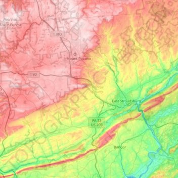
Name: Monroe County topographic map, elevation, terrain.
Location: Monroe County, Pennsylvania, United States (40.81484 -75.64929 41.25213 -74.96660)
Average elevation: 361 m
Minimum elevation: 56 m
Maximum elevation: 684 m
Make a donation
Other topographic maps
Click on a map to view its topography, its elevation and its terrain.
Elkins Park Gardens
United States > Pennsylvania > Montgomery County > Cheltenham Township > Cheltenham
Average elevation: 70 m
Make a donation
Bala Cynwyd
United States > Pennsylvania > Montgomery County > Lower Merion Township
Average elevation: 75 m
Feasterville
United States > Pennsylvania > Bucks County > Lower Southampton Township
Average elevation: 66 m
Hemlock Farms
United States > Pennsylvania > Pike County > Blooming Grove Township
Average elevation: 437 m
Make a donation
Dalmatia
United States > Pennsylvania > Northumberland County > Lower Mahanoy Township
Average elevation: 172 m
Saint Clair
United States > Pennsylvania > Westmoreland County > Hempfield Township
Average elevation: 333 m
Beaver Creek Dam
United States > Pennsylvania > Chester County > West Whiteland Township
Average elevation: 139 m
Make a donation
Make a donation
Airville
United States > Pennsylvania > York County > Lower Chanceford Township > Airville
Average elevation: 209 m
Point View
United States > Pennsylvania > Blair County > Catharine Township > Point View
Average elevation: 372 m
Philadelphia
United States > Pennsylvania > Philadelphia County > Philadelphia
Average elevation: 35 m
East End
United States > Pennsylvania > Centre County > Bellefonte > East End
Average elevation: 303 m
Make a donation
Remeos Mobile Home Park
United States > Pennsylvania > York County > Fairview Township
Average elevation: 133 m