
Thank you for supporting this site ❤️
Make a donation
Make a donation
Gavardo topographic map
Click on the map to display elevation.
Thank you for supporting this site ❤️
Make a donation
Make a donation
Gavardo
Gavardo, located in the lower Valle Sabbia northeast of Brescia, is the most populous town in the area. Characterized by a hilly landscape surrounded by mountains and crossed by the Chiese and Naviglio Grande Bresciano rivers. Elevation is approximately 199 m a.s.l., with the lowest point at 188 m and the highest at 877 m a.s.l. Most of the urban settlement is located along the plain surrounding the Chiese River, while a few small hamlets are located on the surrounding reliefs.
Thank you for supporting this site ❤️
Make a donation
Make a donation
About this map
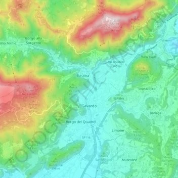
Name: Gavardo topographic map, elevation, terrain.
Average elevation: 386 m
Minimum elevation: 150 m
Maximum elevation: 950 m
Thank you for supporting this site ❤️
Make a donation
Make a donation
Other topographic maps
Click on a map to view its topography, its elevation and its terrain.
Thank you for supporting this site ❤️
Make a donation
Make a donation
Thank you for supporting this site ❤️
Make a donation
Make a donation
Thank you for supporting this site ❤️
Make a donation
Make a donation
Thank you for supporting this site ❤️
Make a donation
Make a donation
Thank you for supporting this site ❤️
Make a donation
Make a donation
Thank you for supporting this site ❤️
Make a donation
Make a donation