
Make a donation
Vladivostok topographic map
Click on the map to display elevation.
Make a donation
Vladivostok
Vladivostok has a monsoon-influenced humid continental climate (Köppen climate classification Dwb, Trewartha climate classification Dcbc) with warm, humid and rainy summers and frigid, dry winters. Owing to the influence of the Siberian High, winters are much colder than a latitude of 43 degrees should warrant, given its low elevation and coastal location, with a January average of −11.9 °C (10.6 °F). Winter temperatures are somewhat colder than Milwaukee and far colder than Florence; all 3 locations are at or above 43 degrees north latitude. They are even colder than those of Moscow and Minneapolis, interior locations at 55 and 44 degrees north, respectively. Since the maritime influence is strong in summer, Vladivostok has a relatively cold annual climate for its latitude. For example, Vladivostok is 9.5 degrees Celsius colder than Sochi in terms of average temperature, and 17.5 degrees Celsius colder in terms of January temperatures, despite both being at 43 degrees North.
Make a donation
About this map
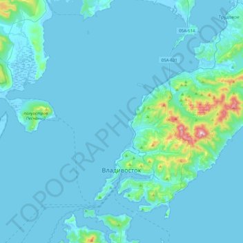
Name: Vladivostok topographic map, elevation, terrain.
Average elevation: 29 m
Minimum elevation: -3 m
Maximum elevation: 450 m
Make a donation