
Thank you for supporting this site ❤️
Make a donation
Make a donation
Park Ridge topographic map
Click on the map to display elevation.
Thank you for supporting this site ❤️
Make a donation
Make a donation
About this map
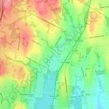
Name: Park Ridge topographic map, elevation, terrain.
Location: Park Ridge, Bergen County, New Jersey, 07656, United States (41.02041 -74.06968 41.04928 -74.01872)
Average elevation: 67 m
Minimum elevation: 16 m
Maximum elevation: 126 m
Thank you for supporting this site ❤️
Make a donation
Make a donation
Other topographic maps
Click on a map to view its topography, its elevation and its terrain.
Township of Washington
United States > New Jersey > Bergen County > Township of Washington
Average elevation: 37 m