
Thank you for supporting this site ❤️
Make a donation
Make a donation
Santa Isabel topographic map
Click on the map to display elevation.
Thank you for supporting this site ❤️
Make a donation
Make a donation
About this map
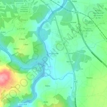
Name: Santa Isabel topographic map, elevation, terrain.
Location: Santa Isabel, Outeiro de Rei, Lugo, Galicia, 27150, España (43.07857 -7.63740 43.11857 -7.59740)
Average elevation: 412 m
Minimum elevation: 377 m
Maximum elevation: 500 m
Thank you for supporting this site ❤️
Make a donation
Make a donation
Other topographic maps
Click on a map to view its topography, its elevation and its terrain.