
Thank you for supporting this site ❤️
Make a donation
Make a donation
Oliver topographic map
Click on the map to display elevation.
Thank you for supporting this site ❤️
Make a donation
Make a donation
About this map
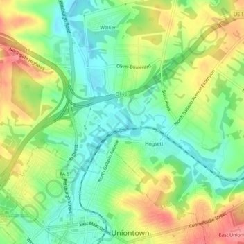
Name: Oliver topographic map, elevation, terrain.
Average elevation: 320 m
Minimum elevation: 284 m
Maximum elevation: 370 m
Thank you for supporting this site ❤️
Make a donation
Make a donation
Other topographic maps
Click on a map to view its topography, its elevation and its terrain.
Mount Braddock
United States > Pennsylvania > Fayette County > North Union Township
Average elevation: 397 m
Lemont Furnace
United States > Pennsylvania > Fayette County > North Union Township
Average elevation: 372 m
Jumonville
United States > Pennsylvania > Fayette County > North Union Township > Jumonville
Average elevation: 613 m