
Fairview Township topographic map
Interactive map
Click on the map to display elevation.
About this map
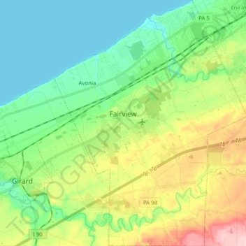
Name: Fairview Township topographic map, elevation, terrain.
Average elevation: 239 m
Minimum elevation: 172 m
Maximum elevation: 386 m
Other topographic maps
Click on a map to view its topography, its elevation and its terrain.
Union City
United States > Pennsylvania > Erie County
Union City, Erie County, Pennsylvania, 16438, United States
Average elevation: 405 m
McKean Township
United States > Pennsylvania > Erie County
McKean Township, Erie County, Pennsylvania, United States
Average elevation: 381 m
Waterford
United States > Pennsylvania > Erie County
Waterford, Erie County, Pennsylvania, United States
Average elevation: 371 m
Edinboro
United States > Pennsylvania > Erie County > Edinboro
Edinboro, Erie County, Pennsylvania, United States
Average elevation: 382 m
Kearsarge
United States > Pennsylvania > Erie County
Kearsarge, Millcreek Township, Erie County, Pennsylvania, 16565, United States
Average elevation: 304 m
Erie
United States > Pennsylvania > Erie County > Erie
Erie, Erie County, Pennsylvania, 16530, United States
Average elevation: 254 m