
Make a donation
Norway topographic map
Click on the map to display elevation.
Make a donation
Norway
At 385,207 square kilometres (148,729 sq mi) (including Svalbard and Jan Mayen; 323,808 square kilometres (125,023 sq mi) without), much of the country is dominated by mountainous or high terrain, with a great variety of natural features caused by prehistoric glaciers and varied topography. The most noticeable of these are the fjords. Sognefjorden is the world's second deepest fjord, and the world's longest at 204 kilometres (127 mi). The lake Hornindalsvatnet is the deepest lake in Europe. Norway has about 400,000 lakes and 239,057 registered islands. Permafrost can be found all year in the higher mountain areas and in the interior of Finnmark county. Numerous glaciers are found in Norway. The land is mostly made of hard granite and gneiss rock, but slate, sandstone, and limestone are also common, and the lowest elevations contain marine deposits.
Make a donation
About this map
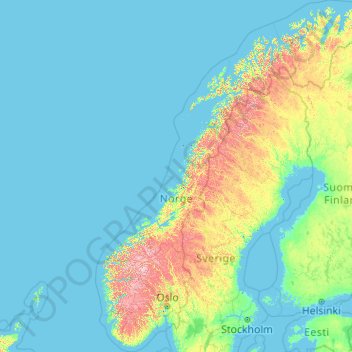
Name: Norway topographic map, elevation, terrain.
Location: Norway (57.75901 4.08753 71.38488 31.76159)
Average elevation: 143 m
Minimum elevation: -3 m
Maximum elevation: 2,267 m
Make a donation
Other topographic maps
Click on a map to view its topography, its elevation and its terrain.
Stavanger
The municipality of Stavanger is located in a coastal landscape, bordering the sea to the west and Boknafjorden in the northeast. The Byfjorden and Gandsfjorden run along the east side of the city. It is part of the Low-Jæren, a flat area of land consisting mostly of marsh, sand, and stone aur, that ranges…
Average elevation: 44 m
Trondheim
Norway > Trøndelag > Trondheim
Trondheim is situated where the River Nidelva meets Trondheim Fjord with an excellent harbour and sheltered condition. The river used to be deep enough for most boats in the Middle Ages. An avalanche of mud and stones made it less navigable and partly ruined the harbour in the mid-17th century. The…
Average elevation: 118 m
Make a donation
Scandinavian Mountains
The mountain chain's highest summits are mostly concentrated in an area (of mean altitude of over 1,000 m) between Stavanger and Trondheim in South Norway, with numerous peaks over 1,300 m and some peaks over 2,000 m. Around Trondheim Fjord, peaks decrease in altitude to about 400–500 m rising again to…
Average elevation: 2,050 m
Make a donation
Make a donation
Make a donation
Galdhøpiggen
At Juvasshytta there is an alpine ski resort with lift on a glacier, reaching an elevation of 2,200 metres (7,200 ft) above sea level, the highest in Scandinavia. It is called Galdhøpiggen Summer Ski Centre and is open from June and all the summer when the road is open.
Average elevation: 2,105 m
Make a donation
Troll tongue
The hike from the parking area to Trolltunga and back again is a 27-kilometre (17 mi) round-trip distance with a 1,100-metre (3,600 ft) gain in elevation, and it takes approximately 10–12 hours, including breaks.
Average elevation: 1,091 m
Make a donation
Make a donation
Make a donation
Make a donation
Make a donation
Make a donation
Make a donation
Make a donation
Make a donation
Make a donation
Make a donation
Scandinavian Mountains
The mountain chain's highest summits are mostly concentrated in an area of mean altitude of over 1,000 m (3,300 ft),) between Stavanger and Trondheim in South Norway, with numerous peaks over 1,300 m (4,300 ft) and some peaks over 2,000 m (6,600 ft). Around Trondheim Fjord, peaks decrease in altitude to about…
Average elevation: 2,050 m
Make a donation
Make a donation
Make a donation
Make a donation
Sognefjorden
The inner end of the Sognefjord is southeast of a mountain range rising to about 2,000 metres (6,600 ft) above sea level and covered by the Jostedalsbreen, continental Europe's largest glacier. Thus the climate of the inner end of Sognefjorden and its branches are not as wet as on the outer coastline.…
Average elevation: 682 m
Make a donation
Troll tongue
The hike from the parking area to Trolltunga and back again is a 27-kilometre (17 mi) round-trip distance with a 1,100-metre (3,600 ft) gain in elevation, and it takes approximately 10–12 hours, including breaks.
Average elevation: 1,091 m
Make a donation
Make a donation
Make a donation
Make a donation