
Provincia de Ferreñafe topographic map
Interactive map
Click on the map to display elevation.
About this map
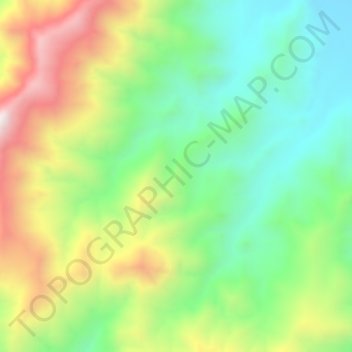
Name: Provincia de Ferreñafe topographic map, elevation, terrain.
Location: Provincia de Ferreñafe, Pítipo, Ferreñafe, Lambayeque, Perú (-6.46712 -79.52704 -6.42712 -79.48704)
Average elevation: 612 m
Minimum elevation: 285 m
Maximum elevation: 1,129 m
Other topographic maps
Click on a map to view its topography, its elevation and its terrain.
Santa Clara
Perú > Lambayeque > Pítipo
Santa Clara, Pítipo, Ferreñafe, Lambayeque, Perú
Average elevation: 91 m
Santuario Histórico Bosque de Pómac
Perú > Lambayeque > Pítipo
Santuario Histórico Bosque de Pómac, Pítipo, Ferreñafe, Lambayeque, Perú
Average elevation: 76 m
La Leche
Perú > Lambayeque > Pítipo
La Leche, Pítipo, Ferreñafe, Lambayeque, Perú
Average elevation: 77 m
La Leche
Perú > Lambayeque > Pítipo
La Leche, Pítipo, Ferreñafe, Lambayeque, Perú
Average elevation: 385 m