
Silver Island topographic map
Interactive map
Click on the map to display elevation.
About this map
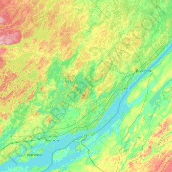
Name: Silver Island topographic map, elevation, terrain.
Average elevation: 113 m
Minimum elevation: 72 m
Maximum elevation: 210 m
Other topographic maps
Click on a map to view its topography, its elevation and its terrain.
Leeds
Canada > Ontario > Leeds and the Thousand Islands
Leeds, Leeds and the Thousand Islands, Leeds and Grenville Counties, Eastern Ontario, Ontario, Canada
Average elevation: 104 m
Leeds and the Thousand Islands
Canada > Ontario > Leeds and the Thousand Islands
Leeds and the Thousand Islands, Leeds and Grenville Counties, Ontario, Canada
Average elevation: 102 m