
Lower Silesian Voivodeship topographic map
Interactive map
Click on the map to display elevation.
About this map
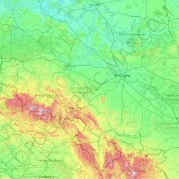
Name: Lower Silesian Voivodeship topographic map, elevation, terrain.
Location: Lower Silesian Voivodeship, Poland (50.09633 14.81737 51.80475 17.79527)
Average elevation: 271 m
Minimum elevation: 56 m
Maximum elevation: 1,523 m
Other topographic maps
Click on a map to view its topography, its elevation and its terrain.
Osada Leśna
Poland > Lublin Voivodeship > Włodawa County > Kołacze > Osada Leśna
Average elevation: 170 m