
Thank you for supporting this site ❤️
Make a donation
Make a donation
Rainsville topographic map
Click on the map to display elevation.
Thank you for supporting this site ❤️
Make a donation
Make a donation
About this map
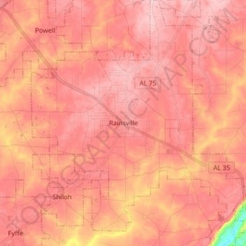
Name: Rainsville topographic map, elevation, terrain.
Location: Rainsville, DeKalb County, Alabama, 35986, United States (34.44824 -85.89977 34.54697 -85.78121)
Average elevation: 382 m
Minimum elevation: 267 m
Maximum elevation: 417 m
Thank you for supporting this site ❤️
Make a donation
Make a donation
Other topographic maps
Click on a map to view its topography, its elevation and its terrain.
Mentone
United States > Alabama > DeKalb County
Mentone is a town in DeKalb County, Alabama, United States. Mentone, located atop Lookout Mountain, has the highest elevation of any incorporated town in Alabama, and narrowly higher than Hytop.
Average elevation: 470 m
Thank you for supporting this site ❤️
Make a donation
Make a donation
Thank you for supporting this site ❤️
Make a donation
Make a donation