
Thank you for supporting this site ❤️
Make a donation
Make a donation
Ceva topographic map
Click on the map to display elevation.
Thank you for supporting this site ❤️
Make a donation
Make a donation
About this map
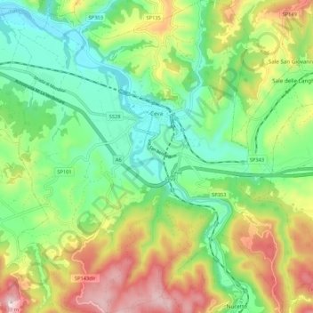
Name: Ceva topographic map, elevation, terrain.
Location: Ceva, Cuneo, Piedmont, 12073, Italy (44.33876 7.98015 44.41476 8.08068)
Average elevation: 524 m
Minimum elevation: 347 m
Maximum elevation: 825 m
Thank you for supporting this site ❤️
Make a donation
Make a donation
Other topographic maps
Click on a map to view its topography, its elevation and its terrain.
Thank you for supporting this site ❤️
Make a donation
Make a donation
Mont Vallonnet Nord / Cima las Blancias
Italy > Piedmont > Cuneo > Pietraporzio
Average elevation: 2,522 m