
Lovran topographic map
Interactive map
Click on the map to display elevation.
About this map
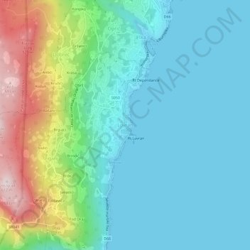
Name: Lovran topographic map, elevation, terrain.
Average elevation: 140 m
Minimum elevation: 0 m
Maximum elevation: 593 m
Other topographic maps
Click on a map to view its topography, its elevation and its terrain.
Krk
Croatia > Primorje-Gorski Kotar County
A Eurasian griffon vulture colony lives in protected in an area called Kuntrep on Krk., There they breed at low elevations, with some nests at 10 m (33 ft). Therefore, contact with people is common.
Average elevation: 95 m